Site Loader

Officially a country in the United Kingdom, the northeast corner of the Emerald Isle is home to jaw-dropping vistas, crumbling castles, and a city with a past so violent it was ranked one of the most dangerous cities in the world. Having undergone a complete transformation nothing short of a miracle, today Belfast is the 2nd safest city in the world after Tokyo, making Northern Ireland one of the most underrated destinations in Europe. 

Northern Ireland stakes its rightful claim as one of the most captivating regions of the world, yet most visitors to Dublin never make the short journey north, except perhaps Game of Thrones fans who know that Northern Ireland is one of the show’s go-to filming locations for its fantastical eye catching backdrops.

The Republic of Ireland is the country that we commonly refer to when we say “Ireland”, and receives the majority of tourists to the island, but for equally stunning views with a fraction of the crowds, you simply can not beat Northern Ireland, a mere 1 hour drive from Dublin, making it a magical day trip.  

ITINERARY

Belfast

Black Cab Tour

Peace Walls

Carrick-a-Rede Rope Bridge

Dunluce Castle

Giant’s Causeway

If you’re visiting Dublin, there is no reason to skip a day trip to Northern Ireland. Rent a car and in an hour you’ll cross the invisible border into the UK, and the only way you’ll know you have is when the road signs change from km to miles and the currency changes from Euros to Great British Pounds.

Perhaps best known for being home to the world’s most famous ship, the Titanic, which was born in the Belfast shipyards, Northern Ireland’s capital and largest city has a turbulent past, but is now a vibrant city complete with Starbucks. Belfast was our first stop in the country, and we picked up a coffee for our Black Cab Tour of the city.

Light hearted but intriguing, a black cab tour is an ideal way to see the the city with a local, especially the Catholic and Protestant neighborhoods that have been bloody battle fronts since the 1970s, and which saw the worst violence in Belfast. We chose Paddy Campbell’s Belfast Famous Black Cab Tours, who has been taxiing guests for almost 30 years, of which a decade includes touring the political murals. Booking the reservation could not have been easier, since it was all via text as we approached Belfast and found our cabbie waiting, in a white cab for the black cab tour.

Their tours are tailored to your interests and needs, based on your conversation with your cabbie. We shared our interests and limitations traveling with our child with Fragile X Syndrome, and set off to explore some of the most reflective sites in the city. Our first stop was the Europa Hotel, which was the hang-out for journalists from all over the world who covered the conflict known as “The Troubles”. The Hotel often made headlines and is dubbed “the world’s most bombed hotel”, having been hit 33 times between 1970 and 1994.

Across the street is Belfast’s most famous bar, the extravagant Victorian style Crown Liquor Saloon that was built in 1885 and adorned with opulent marble, Italian tilework, fine glass engraving, and an embossed ceiling that somehow survived a 1993 bomb. 

To attract a posh clientele from the train station across the street and the Grand Opera House, bells were once connected to the bar so patrons could ring for drinks without leaving their seats. 

“The Troubles” lasted 30 years between 1968-1998 when many nations were also undergoing their own civil rights movements, and during this time many murals were created to denote political loyalties and affiliations. The most famous mural in Belfast is of Bobby Sands, an officer of the Irish Republican Army (IRA) who rose to international prominence in 1981 when he embarked on a fatal hunger strike at the age of 27 after 66 days while imprisoned. His demands included allowing prisoners visits and mail, which he felt were central to improving the inmates’ way of life.

The Troubles is the term given to the conflict between Irish Nationalists and Loyalists to the British Crown in Northern Ireland. Although the conflict often saw Catholic pitted against Protestant, it wasn’t about religion, but instead a political disagreement about whether Northern Ireland should be a part of the UK or part of the Republic of Ireland. The political leaning of the Catholics was largely Irish Nationalist, while the large majority of Protestants identified as British. Our next stop was Clonard Monastery in a Catholic dominated neighborhood of Falls Road. 

The Church of the Holy Redeemer is located at Clonard Monastery and opened in 1911, replacing an earlier church on this site. The British had tried since the 12th century to control its neighbor Ireland, which led to centuries of warfare. British victories in the early 17th century led England to move the Irish Catholic off their lands and replaced them with Protestant settlers from England and Scotland, thereby immediately demoting the now minority Catholic to 2nd class citizens who felt isolated and powerless.

The Church is a beautiful, peaceful space today with its rich wood pews and an abundance of natural light, which is quite fitting since in scripture, God is always symbolized by light.

Our cabbie left us alone inside where we sat in prayer, and were reminded the strength of the prayer is by the love with which you make it. 

After prayers, we lit vigil candles, a traditional that began almost 2,000 years ago when lights were burned in the catacombs at the tomb of martyrs as a sign of unity with them. “Vigil” comes from the Latin word vigilia, which means to “keep watch”, and the faithful light vigil candles as a physical sign of our spiritual prayer.

We admired the rose window and pipe organ as we exited the Church.

Our cabbie’s overview of the region’s history provided context for the sights we saw. While the violence may be gone, the 25 foot walls dividing the warring neighborhoods still stand, and whose gates that once served as checkpoints still lock at night. We continued on in the Catholic Falls Road neighborhood, where you’ll find Irish flags, shamrocks, and lots of green. In the photo below stands the chain wall protecting the community. 

These high fences were added after this working class street close to the Clonard Monastery, Bombay Street, was burned to the ground on 15 August 1969 by a Loyalist mob.


During those 4 decades of community war more than 3,500 people were killed and over 50,000 thousand injured, many of them civilians like the names of the women and children listed below lost from this neighborhood. 

Today you can pay your respects at these memorials.

Our cabbie handed us a plastic and rubber bullet to examine, which were commonly used by Loyalist police during riots for crowd control. While the name may sound gentler, they are in fact gigantic and deadly, blasting a hole larger than any regular bullet would.

We then headed over to the Protestant neighborhood of Shankill Road, where there’s lot of blue, references to English royalty and British Union Jack flags. When Ireland got its independence from Britain in 1921, the northern part of the island remained British, but Catholic pro-Irish republicans wanted Northern Ireland to leave the UK and join Ireland, and Protestant pro-British loyalists wanted Northern Ireland to stay in the UK. The volunteer fighting forces for British loyalists, the Ulster Volunteer Forces, had the British military on their side, who often responded with violence to the Catholic pro-Irish republicans. By 1969, fighting rocked the region, and The Troubles began. The Summer of 69 mural depicts two children no longer able to play outside due to the violence surrounding them.

Adjacent to the Summer of 69 mural, a the Red Hand Commando mural features a British loyalist paramilitary group named after the Red Hand of Ulster symbol.

Another mural in Shankill Road depicts King William riding to victory in 1690 after the Battle of the Boyne, and in the photo you can see Union Jack flags hanging from the homes, as they do from many houses who proudly display these British flags.

Another chilling mural in the Shankill neighborhood is of Stephen McKeag, nicknamed Top Gun, because he shot the most Catholics in Northern Ireland. The artist’s intimidating mural depicts McKeag amid a blue sky background with the words ‘Remember With Pride’ above his head, and the hooded gunman’s barrel in the bottom left mural appears to move with a continued lock on you as you pass.

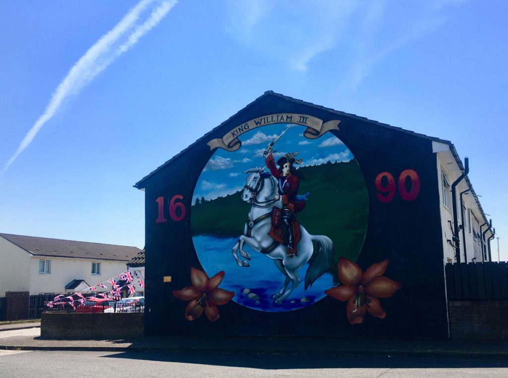
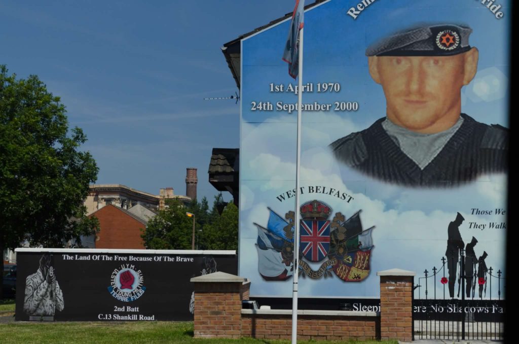
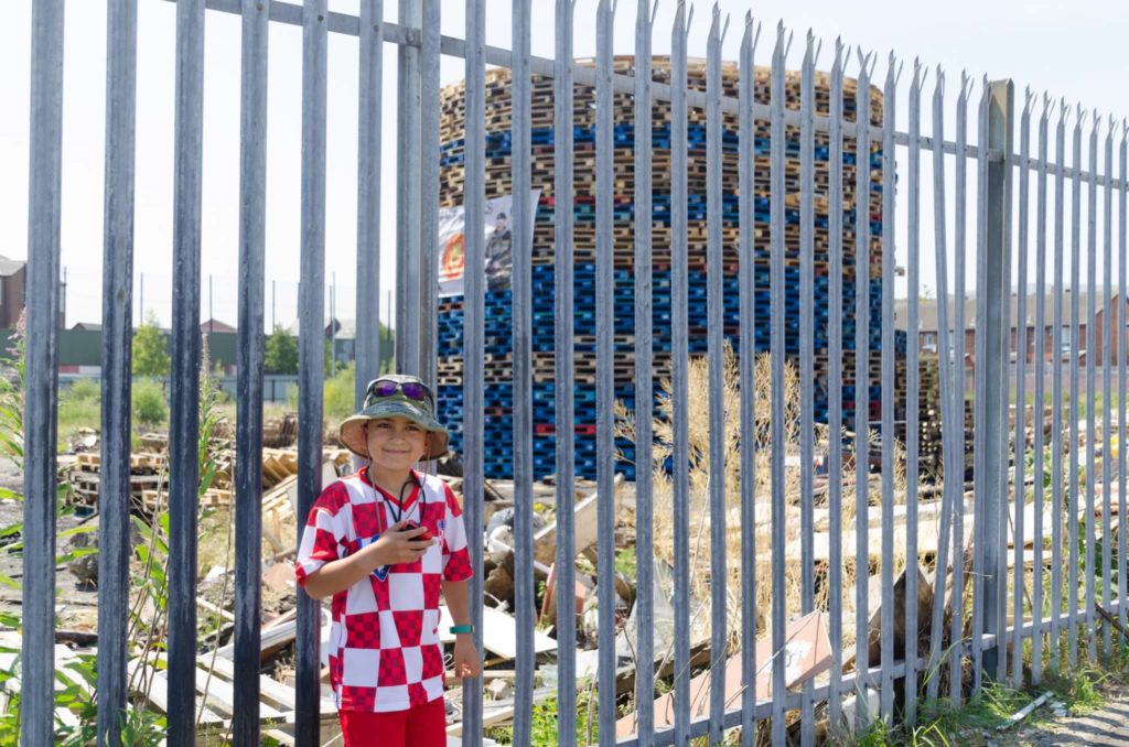
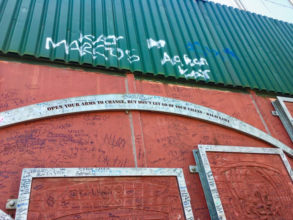
Our trip coincided with “Twelfth Celebrations”, which is when bonfires are lit by Loyalists on July 11th to kick off the celebrations. These celebrations mark the Battle of the Boyne in 1690 when the Protestant William of Orange defeated Catholic King James II. Bonfires were lit to welcome and guide him, but they’re controversial today for a host of reasons, namely safety. This was a small tower under 50 pallets high, but they can be multiple stories high, and the record is 286 pallet high. They’re becoming a thing of the past since these towers are dangerous to construct, often near people or property, and the center is usually stuffed with tires to make them burn more intensely which gives off toxic fumes.

An iconic Belfast experience is a visit to the Peace Wall, and the most famous one divides the Falls Road and Shankill Road neighborhoods that runs half a mile. The wall was designed to separate the communities and built to repel rocks and explosives that had regularly rained down in neighborhoods.

The Peace Walls in Belfast have stood longer than the Berlin Wall ever did, and though they’ve become part of the city’s social fabric, there’s plans to remove them all by 2023. 

However, the 2023 goal seems unattainable since the process has been slow moving, with only a small number eradicated so far. There are inspiring quotes found on the walls that can be embraced to move forward, such as the one below by the Dalai Lama “Open your arms to change, but don’t let go of your values.”

The Peace Walls are listed as one of the Belfast’s top tourist attractions, and visitors are encouraged to sign it or share their own tributes to peace.

You don’t realize how crowded the wall is until you get up close.

We each located a spot to leave our mark on history as we reflected on what we had learned through the day.

No matter which tour you take, you will likely stop at this section of the Peace Wall since it’s one of the only peace walls within the country to have working roads running through it during the day.

Despite what we learned and saw, Belfast appeared to be a happy go lucky city, who has moved on, at least according to the naked eye, made up of a jolly people who were some of the friendliest in the world.

After a couple of hours touring Belfast, it’s a 90 minute drive north to the Causeway Coast, which includes some of the country’s best sights served with dramatic vistas and emerald glens.

The west coast of Ireland gets all the attention, but the northern coast is equally if not more stunning, with 70% of the coastline designated an Area of Outstanding Natural Beauty.

Our first stop along the coast was at the Carrick-a-Rede Rope Bridge, hanging 30 meters above the Atlantic Ocean. 

It’s a scenic 1.25km walk from the parking lot to the bridge, which is closed in high winds.

The rolling green cliffside hills carpeted with bright yellow flowers would have been worth the trip.

Carrick-a-Rede island was created by volcanic activity 60 million years ago. 

First erected by salmon fishermen in 1755 to reduce reliance on a boat to reach the island, the bridge has been used for centuries to catch salmon that would pass through in summer to spawn in the rivers.

Swaying almost 100 feet above pounding waves, this bridge connects the mainland to the tiny island which is also a nesting ground for birds.

Having been to both Ireland and Northern Ireland, these views are some of the most magnificent on the Emerald Isle.

This bridge is the latest in a long line of terrifying bridges to span this gap, and up until the 1970s, the bridge only had one handrail, though shockingly there is no recorded fall from the bridge.

It’s hard to imagine crossing the rope bridge without a railing and netting on both sides considering how much it bounces hanging 100 feet above the sea.

It’s frightening to cross, especially with children as the bridge rocks and sways with each step. 

However, the views from the other side are absolutely worth it, rewarding you with dramatic sea cliffs, deep caves, and rock pinnacles.

Catching 300 salmon a day was common until the 1960’s, when river pollution led to a decline. Only 250 salmon were caught in the entire final season, and in 2002 the last fish was caught at Carrick-a-Rede.

We visited late afternoon, so crowds were pretty light since all of the organized day tours had departed.

You can hang out as long as you’d like on the isolated island soaking in the views.

The name Carrick-a-Rede is from Scottish Gaelic which means “The Rock in the Road”, and it was named as such because it was an obstacle for the migrating salmon as they searched for the river in which they were born.

Today the island is managed by the National Trust, which is a conservation charity working to protect the area and its wildlife. 

There’s only one small building on this island in the North Antrin Coast, which was the home of a fisherman. At it’s fishing peak, there were 100 men working here.

Rathlin Island is straight ahead, and on a clear day like this one you can see the Scottish Isles in the distance.

The National Trust also oversees the safety of tourists visiting, and controls the foot traffic across the bridge.

The views of the coast from the island are spectacular.

This was definitely one of our favorite experiences in Northern Ireland, and if you go late in the day you can avoid the long waits to cross the bridge.

From the bridge, it is just a 10 mile drive along the panoramic coast to the splendid rocky outcrop of Dunluce Castle, featured in Game of Thrones as the castle of Greyjoy. This 13th century medieval castle perched on a dramatic cliff is mostly ruined as a result of a fire in the 1600s.   

This is an ideal location to fly a drone because it’s wide open, and since it was closed when we arrived it was completely empty.

Dunluce Castle was built around 1500 by the MacQuillan Family and later seized by the MacDonnell Clan. According to legend, the castle’s kitchens dropped into the sea, furniture, food, kitchen staff and all one stormy night in 1639.

The MacQuillins were some of the earliest immigrants to America, arriving in Jamestown, Virginia in 1632. 

A village used to surround the castle and was destroyed by fire in 1641. 

A narrow bridge leads from the former guests lodgings and stables on the mainland across a dizzying gap to the main part of the fortress. 

Our last stop for the day was a 10 minute drive to Northern Ireland’s only UNESCO World Heritage Site, the Giant’s Causeway, a spectacular rock formation created millions of years ago. It’s a 15 minute walk from the parking lot to this stunning natural wonder. A shuttle runs from the visitor center, which had closed by the time we arrived at sunset, but we were more than happy to make the quiet leisurely stroll down the hill to enjoy the sunset at the shore.

This geographical phenomenon is considered an 8th wonder of the word, comprised of 40,000 basalt rock columns, and stretches along the coastline like giant stepping stones into the sea. It was created by a volcanic eruption 60 million years ago when lava cooled at a rapid rate causing joints or fractures to form that resulted in these hexagonal columns.

The sight of this science fictional looking creation of interlocking basalt columns with uniquely straight edges was explained a bit differently by ancient populations. We sat down to share with the kids the ancient Celtic legend, which says that an Irish giant, Finn MacCool, was challenged to a fight by a Scottish giant, and so Finn built the Causeway to reach Scotland to accept the challenge. However, when Finn realized his Scottish opponent’s size, he asked his wife to disguise him as a baby. 

When the Scottish giant saw the baby, he fled back to Scotland in fear of what size he imagined a grown giant to be and tore up the Causeway as he left. There are identical basalt columns on the Scottish side, which may have lent itself to the tale.  

The Causeway was said to be discovered in 1692 when the future Archbishop of Dublin visited the area. However, the Causeway had been known to locals for ages, and was referenced in old Irish folklore as the stepping stones of a people who inhabited Ireland before the Celts. 

Sunset is supposed to be a popular time to visit, but we didn’t share it with more than 2 or 3 people that evening. 

Walking on the Giant’s Causeway to the sound of the crashing water of the North Channel as we reflected on our day discovering Northern Ireland, it was clear we could have spent a lot more time in this beautiful, quiet, peaceful country. It won’t be quiet for long though because it’s on the tourist radar now, so Go.

Subscribe

Follow us on the road.

    We respect your privacy. Unsubscribe at any time.